-
Wasserman should go. But what about others in the Epstein files? - 9 mins ago
-
Man charged with attempted murder for allegedly stabbing KFC employee as he left work - 28 mins ago
-
Trump administration alleges LAUSD discriminates against white students - 48 mins ago
-
2026 Daytona 500 on FOX Draws 7.5 Million Viewers, Rivals Olympics Overage - 50 mins ago
-
King’s statement on former Prince Andrew’s arrest shows how grave this crisis is for U.K. royals - about 1 hour ago
-
E-bikes sold by Amazon and Walmart recalled due to explosion, fire risk - about 1 hour ago
-
Long-awaited reports outline problems with Palisades infrastructure - about 1 hour ago
-
Lindsey Vonn’s Tragic Announcement Draws Response From Legendary Athlete - 2 hours ago
-
BetMGM Bonus Code FOXSPORTS Awards up to $1500 in Bomus Bets for USA vs Canada, Women’s Hockey Final - 2 hours ago
-
Olympians going for gold juggle day jobs to bring in some green - 2 hours ago
Winter Storm Maps Show ‘Significant’ Snow Hitting 27 States
More than half of the U.S. is at risk of “significant” snowfall later this week and weekend as meteorologists track another Pacific system set to work its way across the country.
Forecasters say the first risk area centers on a storm tracking from the West Coast, with western and central states currently under a slew of winter storm warnings as the system progresses across the country. In the days to come, AccuWeather meteorologists are warning that the storm’s possible track could bring heavy snow across the Northeast and Mid-Atlantic by this weekend, although several atmospheric conditions would have to align for that to happen.
The storm’s exact path and access to cold air will determine whether major cities along the Interstate 95 corridor see heavy snow late this weekend. The system could tap just enough cold air to generate heavy snowfall from the Appalachians into southern New England.
“There are a lot of pieces to the puzzle that would have to come together at the right time for a major storm to unfold and bring heavy snow late this weekend to early next week,” AccuWeather meteorologist Brandon Buckingham said in the report.
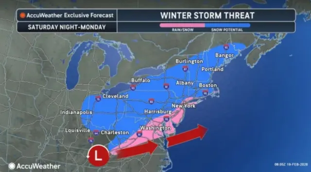
“AccuWeather meteorologists note that several atmospheric components must align for a major snowstorm to unfold,” AccuWeather told Newsweek in an email.
However, if the components do align, the impacts could be far-reaching, spanning the Northeast and Mid-Atlantic.
Maine
Forecasts remain unclear, but according to the map from AccuWeather, the southern half of Maine has the potential for snow from Saturday night until Monday.
New Hampshire
The entire state of New Hampshire faces snow threat this weekend, although exact amounts are unknown at this time.
“From Friday into Saturday, 3-6 inches of snow are forecast from northeastern New York into Vermont, New Hampshire, northern Massachusetts and southwestern Maine,” AccuWeather told Newsweek in an email. “South of the snow zone, rain and drizzle may create icy travel conditions.”
Vermont
Most of Vermont, save for the far northwestern corner, could see heavy snowfall if the conditions develop to continue the winter storm’s trek across the country. The NWS office in Burlington has issued a winter storm watch to be in effect from Friday morning to Saturday morning.
“Heavy snow possible. Total snow accumulations between 4 and 9 inches possible,” the winter storm watch said.
New York
The Burlington winter storm watch also is in effect for parts of northern New York. The NWS office in Albany, New York, also issued a winter storm watch for the same time frame.
“Precipitation will likely begin as wet snow before transitioning briefly over to a wintry mix during the afternoon hours for a mix of freezing rain/rain/snow before returning back to all snow for Friday evening,” the winter storm watch said. “Exact amounts will greatly depend on when moisture arrives and how warm the air temperatures become.”
Nearly all of New York is included in AccuWeather’s map of snow potential this weekend. Southern New York, including New York City, falls within the region at risk of a mix of rain and snow, rather than straight snowfall.
Massachusetts
All of Massachusetts was included in the risk area for snow this weekend, with coastal areas potentially seeing a mix of rain and snow. Although the forecast is unclear, AccuWeather forecasters said the risk is possible for “significant” snow in Boston.
“New York City, Boston and Philadelphia could get significant accumulating snow if the storm tracks just off the coast and taps into sufficient cold air,” AccuWeather told Newsweek in an email.
Connecticut
Connecticut was included in the risk for potential snow this weekend as well.
Rhode Island
Rhode Island also has the risk of seeing heavy snow this weekend if the winter storm arrives.
Delaware
All of Delaware was expecting a mix of snow and rain, according to the AccuWeather map.
Maryland
Maryland’s risk for heavy snow and a snow/rain mix was split, with the western half of the state at risk for snow, with the eastern half possibly seeing a mix.
New Jersey
New Jersey was also split, although most of the state is at risk for snow/rain mix. The NWS office in Mount Holly has a winter weather advisory currently in place, which will go into effect on Thursday evening and persist through Friday at noon.
“Mixed precipitation expected. Total snow and sleet accumulations up to one inch and ice accumulations around two tenths of an inch,” the advisory said.
Pennsylvania
Part of the New Jersey winter weather advisory also was in effect for Pennsylvania. Carbon and Monroe Counties were included in the risk area.
“Plan on slippery road conditions,” the advisory said. “The hazardous conditions could impact the Friday morning commute.”
Virginia
A swathe of central Virginia could see a rain/snow mix this weekend.
West Virginia
Most of West Virginia falls within the risk area of potential snow. If the forecast comes to fruition, some of the highest snowfall amounts will be in the east of the state.
Kentucky
Only far northern and eastern Kentucky fall within the risk area of snow this weekend. However, in the days leading up to the potential winter storm, the state will face a severe thunderstorm threat on Thursday, with Louisville within the highest risk area.
Ohio
The AccuWeather forecast map shows nearly all of Ohio at risk of potential snow this weekend.
Indiana
Only far eastern Indiana is included in the snow potential risk area this weekend. However, similar to Kentucky, the state is facing a severe thunderstorm threat on Thursday, with a tornado or two possible, the NWS warned.
As for the winter storm warnings currently in place, 11 states are affected, with snowfall amounts and location more certain. Snow is expected to continue on Thursday and even into Friday in some cases for Wyoming, Nebraska, Colorado, Michigan, California, Iowa, Utah, Nevada, Alaska, Oregon, and Idaho.
Wyoming
Up to 8 inches of snow and 40 mph winds are expected across the lower elevations of Converse County, and the Sierra Madre range could get up to 12 inches and 50 mph winds until Thursday morning.
The lower elevations of Natrona, southeast Johnson, and southern Campbell Counties could get up to 8 inches of snow and strong winds, reaching 40 mph in some areas, until mid-Thursday morning.
Nebraska
Parts of central, north central, panhandle, and west central Nebraska could see between 4 and 8 inches of accumulated snow, and Greeley, Nance, and Valley Counties could get up to 6 inches of snow—alongside winds reaching 40 mph—through Thursday.
Boone and Platte Counties could see up to 7 inches of snow and 45 mph winds until late Thursday evening, and parts of northeast Nebraska could see up to 4 inches of snow by early Friday morning.
Colorado
Winds reaching 45 mph and up to 3 inches of additional snow are likely to strike Rabbit Ears Pass, and 40 mph winds and up to 2 inches of snow could hit Elkhead and Park Mountains, by Thursday morning.
Michigan
Keweenaw and northern Houghton Counties could get up to 3 inches of snow and 45 mph winds until Thursday afternoon, with the NWS warning that the wintry conditions are likely to affect commutes, especially on Thursday.
California
Snowfall amounts vary widely across California. For example, as little as 3 inches was set to fall across the Riverside and San Bernardino Mountains. However, other parts of California could see snowfall amounts measured in feet, such as up to 3 feet in the highest peaks of Central California and up to 4 feet expected in the highest peaks of Northern California.
Iowa
Commutes in certain areas of Iowa are likely to be impacted on Thursday, as between 2 and 4 inches of snow could fall over southwest parts of the state, and up to 6 inches of snow could fall over Pottawattamie County by Friday morning.
Utah
The Wasatch and Western Uinta Mountains could see up to 3 inches of snow, and the Wasatch Back and Plateau, including Book Cliffs, up to 2 inches of snow by Thursday morning.
Nevada
The Spring Mountains, including Red Rock Canyon, are likely to get up to 1 foot of snow above 8,000 feet with winds reaching 40 mph through Thursday, into Friday morning. The NWS has warned that travel could be “very difficult-to-impossible,” especially along State Routes 156, 157, and 158, plus State Route 160, through Mountain Springs.
Alaska
Between 9 and 15 inches of snow is forecast to fall over the Prince of Wales Island, Sitka, Yakutat, and Cape Fairweather to the Lisianski Strait by Friday morning.
The upper Koyukuk Valley could see between 6 and 10 inches of snow by Thursday morning, and parts of interior Alaska, around the Fairbanks region—including the Chatanika River Valley, Nenana, the White Mountains, and the high terrain south of the Yukon River—could get up to 4 more inches of snow by Friday morning.
The northern borough of Denali could see between 10 and 12 inches of snow, with winds gusting around 35 mph, until Friday morning.
Oregon
According to the NWS, travel could be “impossible” in Glendale and Tiller Counties—as well as areas along the I-5, south of Canyonville, and Canyon Creek Pass—as up to 8 inches of snow, especially above 1,800 feet, are expected to fall by Thursday morning.
Idaho
The Bear River range could see up to 8 inches of snow and winds reaching 45 mph until Thursday morning, which is likely to make travel difficult at times.
Source link
