After a week of stormy weather across California, a break in the clouds provided a glimpse of a mountainous landscape transformed by snow.
The Sierra Nevada mountains were replenished after seeing a dismally low snowpack to start the year, and snow even temporarily closed Yosemite National Park.
New images from NASA show the huge difference a few stormy days can make.
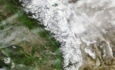
The image below shows the Sierra Nevada range as seen from space on Feb. 12 (left), and 10 days later (right).
By Sunday, the visible snow had expanded significantly down mountain ranges into lower altitudes, and blanketed parts of the Southern Sierra that were barren just 10 days earlier.
Two weeks ago, on Feb. 9, the Sierra Nevada mountains held just 53% of their average historical snow level for that date. By Sunday, the snowpack was at 73% of the typical level, per data from the California Department of Water Resources.
The Northern Sierra lagged behind the rest of the mountain range, seeing just 53% of its typical level of snow as of Sunday. The Central Sierra was at 73%, while the Southern Sierra saw the biggest gain, reaching 98% of its normal snow-pack.
The image below shows the Sierra on Oct. 10, 2025 (left) — before the winter storm season began — and again on Sunday (right).
The change in California’s landscape over four months was stunning, as snow blanketed the Sierra and the Central Valley turned from brown to green.
However, the stormy weather has not been without consequence. Near Lake Tahoe, the snow turned deadly as nine skiers were killed on Feb. 17 in the deadliest avalanche in modern California history.
Later that week, two more skiers died at Heavenly resort’s Boulder Lodge. Authorities have not released more information but were investigating the deaths.