Map Shows Where Canyon Fire Is Burning in Southern California
3 hours ago
3,512
A fast-burning brush fire erupted in California’s Ventura County on Thursday afternoon and quickly spread to 1,500 acres. There was zero containment as of late afternoon and the fire later crossed into Los Angeles County, according to the state Department of Forestry and Fire Protection (Cal Fire).
Evacuation orders have been issued for nine zones and an additional eight zones are under evacuation warnings, the agency said. As of 6:34 p.m. PT, there were no reports of casualties or damage to structures.
Why It Matters
The Canyon Fire is about 90 miles southeast of the massive Gifford Fire, which now covers nearly 100,000 acres. The cause is under investigation.
Temperatures in the area are near 100 degrees and humidity as low as 15 percent. The southern part of California has seen very little rain, drying out vegetation and making it “ripe to burn,” the National Weather Service (NWS) for Los Angeles warned.
What To Know
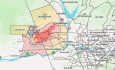
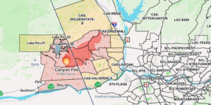
The Canyon Fire started at 1:25 p.m. local time in a remote mountainous area southeast of Piru Lake, north of Highway 126 and west of the town of Castaic. It is being tackled by the Ventura and Los Angeles county fire departments, Cal Fire said.
“The fire is burning east with a rapid rate of spread in light to medium fuels. The onshore push is influencing fire behavior and the fire is threatening 60kv powerlines as well as the communities of Halsley Canyon and Hatthaway Ranch but is moving away from the community of Piru,” the agency added.
Warning of an “immediate threat to life,” Cal Fire said evacuation orders had been issued for the following zones:
PIRU-14
PIRU-01
LAKP-05
LAKP-06
LAKP-04
CAS-VALVERDE
CAS-OAKCANYON
CAS-HASLEY
CAS-ROMERO
A map showing the rapidly spreading Canyon Fire in Ventura and Los Angeles counties in California. A map showing the rapidly spreading Canyon Fire in Ventura and Los Angeles counties in California. Screenshot via California Department of Forestry and Fire Protection
Evacuation warnings had been issued for eight zones:
CAS-INDUSTRY
CAS-GOLDENSTATE-B
CAS-SLOAN
CAS-GREENHILL
CAS-CAMBRIDGE
CAS-HILLCREST
LAKP-01
LAKP-02
What People are Saying
Los Angeles County Supervisor Kathryn Barger urged people to heed evacuation orders: “The Eaton Fire showed us how quickly devastation can strike. It is never worth risking your life, the lives of your loved ones and pets, or the safety of those working to protect you. Your safety is my top priority, and swift action saves lives.”
What Happens Next
Fire risk will be elevated through the weekend across much of inland California as a heat wave intensifies, the NWS warned.
A legjobb élmény biztosítása érdekében olyan technológiákat használunk, mint a cookie-k az eszközadatok tárolására és/vagy eléréséhez. Ha beleegyezik ezekbe a technológiákba, akkor olyan adatokat dolgozhatunk fel ezen az oldalon, mint a böngészési viselkedés vagy az egyedi azonosítók. A hozzájárulás elmulasztása vagy visszavonása bizonyos funkciókat és funkciókat hátrányosan érinthet.
Functional
Always active
The technical storage or access is strictly necessary for the legitimate purpose of enabling the use of a specific service explicitly requested by the subscriber or user, or for the sole purpose of carrying out the transmission of a communication over an electronic communications network.
Preferences
The technical storage or access is necessary for the legitimate purpose of storing preferences that are not requested by the subscriber or user.
Statistics
The technical storage or access that is used exclusively for statistical purposes.The technical storage or access that is used exclusively for anonymous statistical purposes. Without a subpoena, voluntary compliance on the part of your Internet Service Provider, or additional records from a third party, information stored or retrieved for this purpose alone cannot usually be used to identify you.
Marketing
The technical storage or access is required to create user profiles to send advertising, or to track the user on a website or across several websites for similar marketing purposes.