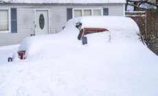
Winter storm warnings have been issued to 11 states as up to 4 feet of snow, and strong winds reaching 70 mph are expected to strike from Thursday, which could be life-threatening to those caught unprepared for severe winter conditions,” according to the National Weather Service (NWS).
States Affected by Winter Storm Warnings
The NWS warns that the following 11 states could face severe winter weather conditions through Thursday, and into Friday in some cases: Wyoming, Nebraska, Colorado, Michigan, California, Iowa, Utah, Nevada, Alaska, Oregon, and Idaho.
It says that roads in affected areas are expected to become hazardous, and visibility significantly reduced due to heavy falling and blowing snow, making travel treacherous.
Wyoming
Up to 8 inches of snow and 40 mph winds are expected across the lower elevations of Converse County, and the Sierra Madre range could get up to 12 inches and 50 mph winds until Thursday morning.
The lower elevations of Natrona, southeast Johnson, and southern Campbell Counties could get up to 8 inches of snow and strong winds, reaching 40 mph in some areas, until mid-Thursday morning.
Nebraska
Parts of central, north central, panhandle, and west central Nebraska could see between 4 and 8 inches of accumulated snow, and Greeley, Nance, and Valley Counties could get up to 6 inches of snow—alongside winds reaching 40 mph—through Thursday.
Boone and Platte Counties could see up to 7 inches of snow and 45 mph winds until late Thursday evening, and parts of northeast Nebraska could see up to 4 inches of snow by early Friday morning.
Colorado
Winds reaching 45 mph and up to 3 inches of additional snow are likely to strike Rabbit Ears Pass, and 40 mph winds and up to 2 inches of snow could hit Elkhead and Park Mountains, by Thursday morning.
Michigan
Keweenaw and northern Houghton Counties could get up to 3 inches of snow and 45 mph winds until Thursday afternoon, with the NWS warning that the wintry conditions are likely to affect commutes, especially on Thursday.
California
Between 3 and 8 inches of snow could fall across the Riverside and San Bernardino Mountains—along with 75 mph winds—lasting until Friday morning, resulting in blowing snow, reduced visibility, and hazardous conditions.
Parts of central California could see winds reaching 50 mph and snow levels reaching 3 feet, over the highest peaks, until Thursday night, and Frazier Mountain, the Piute Walker Basin, and Tehachapi communities could get up to 18 inches of snow, in areas above 6,000 feet, and 55 mph winds until Friday morning.
Western parts of Siskiyou County could get up to 12 inches of snow, in areas above 3,000 feet, and southern and eastern Siskiyou—including Highways 97 and 89, and Interstate 5, south of Weed—could see up to 20 inches of snow in the highest elevations by Thursday morning.
Between 4 and 10 inches of snow could fall in areas across the Humboldt and Del Norte Interior by Thursday morning, the NWS has advised people to consider delaying travel, but if it is “absolutely necessary,” drivers should use “extreme caution.”
Parts of Northern California could get up to 4 feet of snow along the highest peaks, with winds reaching 55 mph, until mid-Thursday morning, and the Interstate 5 Corridor, Santa Barbara, and the interior and southern Ventura Mountains could get up to 12 inches of snow and winds reaching 70 mph, lasting until Friday morning.
The foothills of the eastern and western Antelope Valley, the western San Gabriel Mountains, and the Highway 14 Corridor could see up to 8 inches of snow in areas above 4,500 feet and 70 mph winds until Friday morning.
Up to 2 feet of snow are expected to fall in areas above 6,000 feet over the eastern San Gabriel Mountains and northern Ventura Mountains, with 60 to 70 mph winds, until Friday morning.
Iowa
Commutes in certain areas of Iowa are likely to be impacted on Thursday, as between 2 and 4 inches of snow could fall over southwest parts of the state, and up to 6 inches of snow could fall over Pottawattamie County by Friday morning.
Utah
The Wasatch and Western Uinta Mountains could see up to 3 inches of snow, and the Wasatch Back and Plateau, including Book Cliffs, up to 2 inches of snow by Thursday morning.
Nevada
The Spring Mountains, including Red Rock Canyon, are likely to get up to 1 foot of snow above 8,000 feet with winds reaching 40 mph through Thursday, into Friday morning. The NWS has warned that travel could be “very difficult-to-impossible,” especially along State Routes 156, 157, and 158, plus State Route 160, through Mountain Springs.
Alaska
Between 9 and 15 inches of snow is forecast to fall over the Prince of Wales Island, Sitka, Yakutat, and Cape Fairweather to the Lisianski Strait by Friday morning.
The upper Koyukuk Valley could see between 6 and 10 inches of snow by Thursday morning, and parts of interior Alaska, around the Fairbanks region—including the Chatanika River Valley, Nenana, the White Mountains, and the high terrain south of the Yukon River—could get up to 4 more inches of snow by Friday morning.
The northern borough of Denali could see between 10 and 12 inches of snow, with winds gusting around 35 mph, until Friday morning.
Oregon
According to the NWS, travel could be “impossible” in Glendale and Tiller Counties—as well as areas along the I-5, south of Canyonville, and Canyon Creek Pass—as up to 8 inches of snow, especially above 1,800 feet, are expected to fall by Thursday morning.
Idaho
The Bear River Range could see up to 8 inches of snow and winds reaching 45 mph until Thursday morning, which is likely to make travel difficult at times.
In a polarized era, the center is dismissed as bland. At Newsweek, ours is different: The Courageous Center—it’s not “both sides,” it’s sharp, challenging and alive with ideas. We follow facts, not factions. If that sounds like the kind of journalism you want to see thrive, we need you.
When you become a Newsweek Member, you support a mission to keep the center strong and vibrant. Members enjoy: Ad-free browsing, exclusive content and editor conversations. Help keep the center courageous. Join today.