Salvaging a crumbling California coastline required some radical thinking
2 hours ago
4,197
When the fires this year upended Los Angeles and put into question what it even means to return to normal, I was reminded of a chapter in “California Against the Sea” that had expanded my own understanding of what it takes to truly adapt our built environment — and to reimagine the places that we have come to love and call home.
This chapter, which opens with a radical shoreline reconfiguration just north of San Francisco, came not without controversy, but it provided a glimpse into what compromise might need to look like for so many communities struggling to keep up with climate change. Rather than hold the line with increasing futility, here was a humbling example of what can be possible when we transcend the throes of politics — and when we choose to set aside our differences and think beyond just reacting to the same disasters time and time again.
Since the book was published in 2023, the bridge described in the following excerpt has been completed, and the creek is finally free. Accommodating nature in this way called for some tough and unfamiliar changes, but go out to the beach today, and you can see the marsh starting to recover and the entire ecosystem gently resetting with the rhythms of the sea.
So much of the climate debate is still framed around what it is that we have to give up, but does it have to be this way? Rather than confront these decisions as though it’s our doom, can we embrace change and reconsider each effort to adapt as an opportunity — an opportunity to come together and build more bridges to the future?
A few winding turns past Bodega Bay, about an hour north of San Francisco, relentless waves pound against a stretch of coastline in dire need of re-imagining. Gleason Beach, once reminiscent of a northern version of Malibu, is now mostly just a beach in name. Sand emerges only during the lowest of tides. Bits of concrete and rebar are all that remain of 11 clifftop homes that once faced the sea. A graveyard of seawalls, smashed into pieces, litters the shore. Here along the foggy bluffs of the Sonoma coast, the edge of the continent feels more like the edge of the world — a window into the future if California does not change course.
Los Angeles knows how to weather a crisis — or two or three. Angelenos are tapping into that resilience, striving to build a city for everyone.
These wave-cut cliffs, a brittle mélange of ancient claystone and shale, have been eroding on average about a foot a year, exacerbated since the 1980s by a hardened shoreline, intensifying El Niños and, now, sea level rise. With the beach underwater, the seawalls destroyed and so many homes surrendered, the pressure is now on Highway 1 to hold the line between land and sea. Year after year, residents have watched the waves carve away at the two-lane road — their only way to get to work, their only way to evacuate, their only way to reach all the rocky coves, beaches and seaside campgrounds that make this coast a marvel.
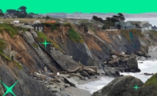
Broken concrete is all that’s left of a number of clifftop homes at Gleason Beach on the Sonoma Coast, pictured here in 2019.
(Carolyn Cole/ Los Angeles Times)
So, with every storm and every knock from the ocean, officials have scrambled to save the highway, pouring millions of tax dollars into a vicious cycle of sudden collapses and emergency repairs. From 2004 to 2018 alone, state transportation officials spent about $10 million in emergency defenses and failed repairs. In 2019, almost half a mile had to be reduced to one lane.
This lifeline for the region now hangs inches from the edge. The once spectacular coastline had seemingly morphed overnight — an apocalyptic transformation, decades in the making, seen with stark clarity now that orange caution tape and makeshift traffic lights mark what’s left of the shore.
“This is what unmanaged retreat looks like, and it is quite frankly a hot mess of septic systems, old house parts and armoring that have fallen into the intertidal zone with no real mechanism for cleaning it up,” Sonoma County supervisor Lynda Hopkins declared. “If we don’t start planning ahead and taking proactive measures, Mother Nature will make the decisions for us.”
With the realities of climate change looming ever closer, California transportation officials agreed it was time to try something different: make peace with the sea and move the crumbling highway more than 350 feet inland. They knew nailing down the details would be fraught, but, if done right, this would be the first radical effort by the state to plan for a reimagined coast — a coast that could support California into the next century. It was the rare managed retreat proposal that intentionally sought to both raise and relocate critical infrastructure far enough from the shore to make room for the next 100 years of rising water.
Compromise wasn’t easy. Officials studied more than 20 alternatives that tried to balance safety codes, traffic needs, fragile habitats, public access to the coast and other competing requirements that were tricky to meet given the topography. There were also all the nearby property owners who needed persuading, not to mention a skeptical, conservation-minded community that was averse to saving a human-altered shoreline with more human alterations. They ran into every argument and counterargument that have tugged, pulled and paralyzed other communities.
At its heart this project, like so many attempts along the California coast, called for a reckoning over what was worth saving — and what was worth sacrificing — and whether it was possible to redesign a treasured landscape so that it survives into the future.
Book cover for “California Against the Sea” by Rosanna Xia
(Heyday Books)
“It seems daunting; it’s a lot of change to cope with, but it’s also an opportunity for communities to think about, ‘What are the coastal resources we want to have access to fifty, one hundred years from now?’” said Tami Grove, who oversees transportation projects for the California Coastal Commission and spent years reconciling all the emotional meetings, the disagreements, the many stops and stalls and hand-wringing compromises. “It gets lost, sometimes, when people are worried about everything that we’re going to lose to sea level rise — but there are things that we’re going to be able to choose and enhance and design into the future if we start planning now.”
In what many described as a major coup in government bureaucracy, the California Department of Transportation (Caltrans), the coastal commission and county leaders set aside their differences to come up with a new solution together. By November 2020, they had hammered out a plan to relocate almost one mile of the highway — most notably with a new 850-foot-long bridge spanning Scotty Creek, a degraded stream that, choked for decades by the highway’s current configuration, rarely reached the ocean anymore. Rather than agonize over how to restore the landscape to some former, unobtainable baseline of “natural,” officials unanimously agreed that this bold re-imagining of the coast was the best way forward among no perfect options.
The concrete bridge (a monstrous overpass or a reasonable compromise, depending on who’s talking) will at least allow Scotty Creek to flow freely into the ocean again — making room for more red-legged frogs, Myrtle’s silverspot butterflies, and the passage of steelhead trout and coho salmon. Officials reasoned that elevating the highway would avoid paving over what’s left of the wetlands, which were already in desperate need of healing. By rerouting traffic onto a bridge, these drowning habitats would have the space to recover and migrate inland as the sea moved in.
State transportation officials also agreed, as part of the $73 million project, to pay $5 million to help clean up the mess of abandoned homes and failed road repairs. An additional $6.5 million will go toward wetland, creek and prairie restoration. Some of the old highway will be converted into a public coastal trail, and visitors will have access to a new parking area, as well as a beach that was once limited by private property.
Caltrans also set aside money to negotiate and acquire land from three private properties, including oceanfront portions of a historic ranch that will be most impacted by the realigned highway. Once completed, much of the open space will be transferred to Sonoma County to manage on behalf of the public.
This all came as a shock at first for Philip and Roberta Ballard, who own and live on the ranch, but they said they’ve come to understand the necessity of this project. The bridge still feels way too big — especially for this rural stretch of paradise that first captured their hearts more than two decades ago — but after years of meetings, questions and debating each trade-off, the retired couple decided to turn their energies toward making sure Scotty Creek got restored as part of the deal.
The creek, the largest watershed between Salmon Creek and the Russian River, has needed help since before they purchased the ranch, they said. In a past life, steelhead trout and coho salmon thrived in this stream. The once-abundant fish disappeared after the concrete culvert, installed in 1952 to support the highway, blocked their ability to migrate between fresh- and saltwater. The brackish habitat drowned over the decades. Then the creek, swollen after a series of big storms in the 1980s, flooded the lower plain. The stream banks were denuded of vegetation and the riffle crests obliterated as the choked stream tried to reach the sea.
Since 2004, the Ballards, both professors emeriti of pediatrics at UC San Francisco, have been piecing together ways to restore the creek, one small project at a time. Full restoration would require grading and reshaping the riverbanks, bringing back the native vegetation, improving water flow and re-creating the pools that once provided shelter to juvenile fish. The $6.5 million that Caltrans promised as part of the final deal will go a long way, they said, to nursing this entire ecosystem back to life.
“A lot of our efforts have gone into trying to make the best out of something that is necessary,” Roberta Ballard said. “We’ve arrived at feeling reasonably good about getting the best mitigation we can get for this region and getting something reasonably positive out of it.”
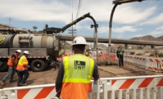
Construction crews work on building a new bridge over Scotty Creek, as part of Caltrans’ Gleason Beach Roadway Realignment Project.
(John Huseby / Caltrans)
When we don’t understand and don’t allow for the ocean’s ways, we end up with homes perched on crumbling cliffs and seawalls still making a stand. Guided by a few mere decades of history and a narrow understanding of the California shore, many today know only how to preserve the version of the coast they learned to love. Rather than imagine a different way to live, we cling to the fragility of what we still have and account for only what we consider lost. Even remembering how wide a beach used to be, or how the cliffs once withstood the tide, glorifies the notion that resilience is measured by our ability to remain unchanged.
We fail to see how we’ve replaced entire ecological systems with our own hardened habitats, and then altered the shoreline even more once the shore began to disappear. Neither replicating the past nor holding on to the present is going to get us to the future that we need. Learning from the recurring cycles of nature, listening to the knowledge gained with each flood and storm, adapting and choosing to transform — this is what it means to persevere. Change, in the end, has been the only constant in our battle for permanence. Change is the only way California will learn how to live with, not on, this beautiful, vanishing coastline that so many people settled and still wish to call home.
Stefan Galvez-Abadia, Caltrans’s district division chief of environmental planning and engineering, is now attempting with his team to design a prettier bridge at Gleason Beach, one more fitting for the rural landscape. They’ve studied the arched columns of Bixby Creek Bridge on the Big Sur coast and other popular landmarks that have become iconic over time. They’ve conducted surveys on what color to paint the bridge — some shade of gray or brown, for example, or a more distinct hue like that of the Golden Gate Bridge. Donne Brownsey, who served as vice chair of the Coastal Commission at the time, remarked that the project reminded her of a concrete beam bridge in Mendocino County that spans the mouth of the Ten Mile River, just north of where she lives in Fort Bragg. “It was a new bridge, it caused a lot of consternation, but I didn’t know that the first few times I went over it — I would look forward to that part of the drive, because I could see the whole estuary to the west, and I could see the rivershed to the east,” she said. “You don’t even really see the bridge anymore because the swallows now all nest there, and it’s just part of nature.”
The bridge at Gleason Beach, facing similar design constraints as the Ten Mile Bridge, also has to be massive — a counter-intuitive twist to what one might think it means to accommodate the environment. Engineers had at first tried more minimal options — a shorter bridge, thinner columns, a less intrusive height — but many were not large enough in size or distance to outlast the coastal erosion projected for the next 100 years. And to give the wetlands enough space to grow back, the highway needed to be elevated at a landscape-wide scale.
The completed bridge and realignment of Highway 1 can now be seen at Gleason Beach, about an hour north of San Francisco.
(Caltrans)
Despite so many years of seminars and talks about climate change adaptation, turning an abstract concept like managed retreat into reality has been a delicate exercise in compromise, Galvez-Abadia said. There were few case studies to turn to, and each one he examined dealt with an increasingly complicated set of trade-offs.
“You don’t have many choices when it comes to sea level rise,” he said, flipping through almost two dozen renderings his team had tried. “Whichever way you choose, you’re going to have some kind of impact. These are the difficult decisions that we will all have to make as a region, as a community, for generations to come.”
As he filed away his notes and prepared to break ground, he reflected once more on all the years it took to reach this first milestone. The process wasn’t easy. A lot of people are still frustrated. Even more are disappointed. Many tough property negotiations still lay ahead, but he hoped, at least, to see the wetlands and creek recover beneath the bridge one day. If the native plants reemerge, the salmon return, and there still remains a coast that families could safely access and enjoy, perhaps this new highway — however bold, however different — could show California that it is possible, that it isn’t absurd, to build toward a future where nature and modern human needs could finally coexist.
A legjobb élmény biztosítása érdekében olyan technológiákat használunk, mint a cookie-k az eszközadatok tárolására és/vagy eléréséhez. Ha beleegyezik ezekbe a technológiákba, akkor olyan adatokat dolgozhatunk fel ezen az oldalon, mint a böngészési viselkedés vagy az egyedi azonosítók. A hozzájárulás elmulasztása vagy visszavonása bizonyos funkciókat és funkciókat hátrányosan érinthet.
Functional
Always active
The technical storage or access is strictly necessary for the legitimate purpose of enabling the use of a specific service explicitly requested by the subscriber or user, or for the sole purpose of carrying out the transmission of a communication over an electronic communications network.
Preferences
The technical storage or access is necessary for the legitimate purpose of storing preferences that are not requested by the subscriber or user.
Statistics
The technical storage or access that is used exclusively for statistical purposes.The technical storage or access that is used exclusively for anonymous statistical purposes. Without a subpoena, voluntary compliance on the part of your Internet Service Provider, or additional records from a third party, information stored or retrieved for this purpose alone cannot usually be used to identify you.
Marketing
The technical storage or access is required to create user profiles to send advertising, or to track the user on a website or across several websites for similar marketing purposes.