Hurricane Melissa is a mighty Category 5 storm in the Caribbean. Maps show its forecast path.
3 hours ago
2,879
Melissa strengthened into a Category 5 hurricane on Monday and was forecast to bring “life-threatening and potentially catastrophic” flash flooding and landslides to Jamaica, the southern parts of Haiti and the Dominican Republic and to eastern Cuba over the next few days, the Miami-based National Hurricane Center warned.
Hurricane Melissa, the 13th named storm of the Atlantic season, isn’t expected to have major impacts on the mainland United States, but it’s turning into the strongest Atlantic system this season.
Melissa’s forecast and path
The storm had maximum sustained winds of 175 mph as of the NHC’s 5 p.m. ET update Monday. Hurricanes reach Category 5 — the top of the Saffir-Simpson Hurricane Wind Scale — when their winds hit 157 mph.
Melissa’s center was about 140 miles southwest of Kingston, Jamaica, and about 320 miles southwest of Guantanamo, Cuba, as of the latest hurricane center update. Hurricane-force winds extended some 30 miles from the storm’s center, and tropical storm-force winds extended 195 miles. The storm was crawling northwest at 3 mph.
Map shows the forecast path for Hurricane Melissa as it approaches Jamaica.
CBS News
“The core of Melissa is expected to move over Jamaica tonight and Tuesday, across southeastern Cuba Tuesday night, and across the southeastern Bahamas on Wednesday,” the hurricane center said.
Forecasters said the storm’s intensity would likely fluctuate ahead of its landfall. But, they added, “Melissa is expected to reach Jamaica and southeastern Cuba as an extremely powerful major hurricane, and will still be at hurricane strength when it moves across the southeastern Bahamas.”
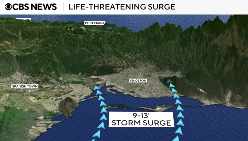
When Melissa makes landfall, peak storm surge accompanied by destructive waves are forecast to reach 9 to 13 feet above ground level in Jamaica and 6 to 9 feet in Cuba.
The storm’s slow pace also raises the risk of destructive impacts, particularly in Jamaica.
“The devastation is going to be so profound because the storm is moving slowly,” CBS News Philadelphia meteorologist Grant Gilmore said Monday. “It’s going to remain at a very slow pace as it traverses the island. … All of the threats that a hurricane can unleash on an island, it’s all going to happen in Jamaica over the next 36 hours.”
Melissa could be the most powerful hurricane ever to hit Jamaica.
“The island’s terrain makes it even worse,” CBS News Philadelphia meteorologist Andrew Kozak explained. “Jamaica’s mountains force the air to rise, and that creates more rain.”
The strongest previous hurricane to pound Jamaica was Gilbert in 1988, Kozak said. It killed 45 people and caused more than $700 million in damage.
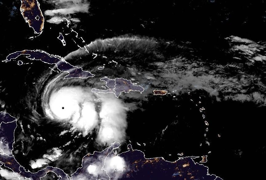
Hurricane Melissa as seen from a satellite at 5:10 a.m. EDT on Oct. 27, 2025.
NOAA / National Hurricane Center
Hurricane advisories
A hurricane warning is in effect for Jamaica and the Cuban provinces of Granma, Santiago de Cuba, Guantanamo, and Holguin.
A hurricane warning is in effect for the southeastern and central Bahamas, according to the Meteorological Service of the Bahamas. A tropical storm warning was issued for the Turks and Caicos islands, Haiti and the Cuban province of Las Tunas.
The Naval Station Guantanamo Bay said it was moving “non-mission-essential” U.S. citizens off the island in groups ahead of severe weather from Melissa.
Map shows risk of storm surge from Hurricane Melissa.
CBS News
Rainfall forecasts
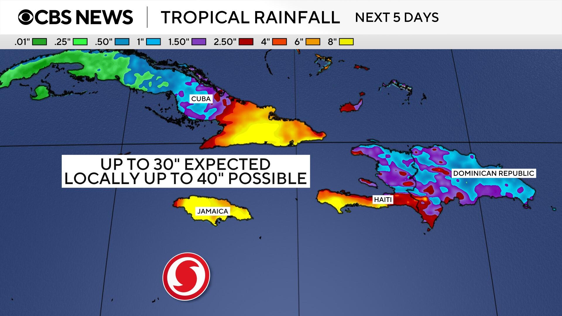
Melissa is expected to bring 15 to 30 inches of rain to areas of Jamaica and 8 to 16 inches for southern Hispaniola (the island split into Haiti and the Dominican Republic) through Wednesday, with a total of 40 inches possible in some places, the hurricane center said. For eastern Cuba, total rainfall could reach 10 to 15 inches, with as much as 20 inches in some spots today into Wednesday, the center added.
Map shows potential rainfall totals from Hurricane Melissa in Jamaica.
CBS News
“Over the Southeast Bahamas, total rainfall of 4 to 8 inches is expected Tuesday into Wednesday, resulting in areas of flash flooding.”
“Catastrophic flash flooding and landslides are probable across portions of southern Hispaniola and Jamaica,” forecasters said.
Additional heavy rainfall is likely beyond Tuesday, the hurricane center said, but uncertainty remains about the more extended forecast.
A legjobb élmény biztosítása érdekében olyan technológiákat használunk, mint a cookie-k az eszközadatok tárolására és/vagy eléréséhez. Ha beleegyezik ezekbe a technológiákba, akkor olyan adatokat dolgozhatunk fel ezen az oldalon, mint a böngészési viselkedés vagy az egyedi azonosítók. A hozzájárulás elmulasztása vagy visszavonása bizonyos funkciókat és funkciókat hátrányosan érinthet.
Functional
Always active
The technical storage or access is strictly necessary for the legitimate purpose of enabling the use of a specific service explicitly requested by the subscriber or user, or for the sole purpose of carrying out the transmission of a communication over an electronic communications network.
Preferences
The technical storage or access is necessary for the legitimate purpose of storing preferences that are not requested by the subscriber or user.
Statistics
The technical storage or access that is used exclusively for statistical purposes.The technical storage or access that is used exclusively for anonymous statistical purposes. Without a subpoena, voluntary compliance on the part of your Internet Service Provider, or additional records from a third party, information stored or retrieved for this purpose alone cannot usually be used to identify you.
Marketing
The technical storage or access is required to create user profiles to send advertising, or to track the user on a website or across several websites for similar marketing purposes.